|
|
|
According to a report dated 23 April 2022 is the structural damages of the forward bulkhead of the Estonia caused by an explosion and explosives under water, i.e. the visor didn"t drop off due to "wave impacts"! UPDATE to the INVESTIGATION REPORT ON THE CAPSIZING ON 28 SEPTEMBER 1994 IN THE BALTIC SEA OF THE RO-RO PASSENGER VESSEL MV E S T O N I A by the German 'Group of Experts' dated May 2000 and available in the Internet under htttp://estoniaferrydisaster.net since that time. THIS UPDATE COVERS THE TIME FROM JUNE 2000 - DECEMBER 2006 So when the ship sank the visor was still attached to it! ... ? But according all experts the visor was lost >30 minutes earlier ... ?
(to hide the true cause of accident!) - June 5 2008 And how Strathclyde University, assisted by its Pricipal, faked the computer animations of the SSPA model tests (December 2010)
The visor was found at the M/S Estonia
wreck after the accident and was blown off the wreck using
explosives under water by Swedish Royal Navy
divers (This web page was originaly published around 2000 and was updated October 2022) The M/S Estonia was sunk due to saboatge in the Baltic on 28 September 1994 under very mysterious circumstances. The Swedish prime minister Carl Bildt announced the same morning that the bow visor of the ferry had dropped off and caused the incident. The ferry was floating on the visor and when it dropped off the ship sank! Only a complete idiot would suggest somthing like it, but the lie worked 1994 ... and 2022. The wreck was found and filmed by sonar the Finnish rescue forces some days later on the sea floor at about 60 meters depth. The Finnish spokesperson informed that the bow visor of the ferry of the wreck was missing. The same Finnish rescue forces then two weeks later allegedly found the missing bow visor 1.800 meters west of the wreck according to the same spokesperson. But the spokesperson lied. No visor was missing and found 1 800 meters west of the wreck. Why did the Finns lie? The ferry frequently carried ex USSR military material from Tallinn to Stockholm, some of it on behalf of the Swedish Armed Forces. Immediately, without any evidence, the authorities stated that the bow visor locks had caused the accident. The locks had been broken in very severe weather when enormous >1 000 tons wave impacts had knocked of the visor allowing >1 000 tons water to enter the superstructure, after the visor fell off. The ferry had then, without visor, continued forward, turned 180° port and capsized to starboard to be floating upside down. The upside down but floating ferry had finally drifted at 2 knots speed and suddenly sunk 1 800 meters east of the visor. However in my opinion the visor
had nothing to do with the accident. Or any, very
severe weather! Map of
fake trajectory of the sinking prepared by
Estonian, Finnish and Swedish accident
investigators All is a hoax or fairy tale
invented by the Swedish government 1994. In
reality the ferry sank due to two hull leakages
caused one way or another - sabotage. The
visor was found still attached at the
sunken wreck (sic) by the
Finnish rescue forces! But the spoke person of the
Finns lied and said the the visor was
missing. The visor was simply
removed
from the wreck under water by
Swedish Navy divers after the
accident. The German experts working for the shipyard that built the ferry thought later that the visor fell off by itself, when the ship was sinking for other reasons. The Germans have also established that the visor was never locked - it was damaged prior the incident - but kept in place by ropes and fairly easy to remove from the wreck under water by Swedish divers. It explains all lies and official false information about the sinking presented 1994-2014-2022 by Swedish and Finnish authorities. There is no evidence that the visor was found 18 October 1994 1 800 m west of the wreck and later picked up there. To support the official lies many surviving Estonian crewmembers were then kidnapped by Swedish and Finnish authorities later on the day of the event. Other Estonian crewmembers were forced to lie about what had happened. All information was then falsified to support the official story, i.e. the hoax. No proper accident investigation was ever done - just a Final report was published December 1997, where every essential presented fact is unproven ... simply invented to suit the fairy tale. This web page of mine is about official pictures of the wreck, visor and its surroundings. For more info click here. The sea floor >150 meters South of the M/S Estonia wreck has changed considerably since the accident 1994 indicating a lot of underwater activity after the accident. The official story is that 'preparation work' to cover the wreck was carried out in April to June 1996 and that 380 000 tons of stone, sand or similar were deposited on the sea floor around the wreck. Around the actual wreck there is little trace of this activity. The bottom seems to be unchanged from 1994 to today. But 'pyramid' or visor shaped objects at the wreck can been seen on the barimetric charts of the wreck published after 1996! Very strange! Officially the visor was lost from the ship before its sinking 1 560 meters East of the visor. The visor was thus officially located and salvaged 1 560 meters West of the wreck. But pictures of something looking like the visor at the wreck exist. Below you see a picture of a 'visor' or pyramid shaped object at the wreck's bow on the bottom of the sea in 1996 or 2000 - two or six years after the visor was salvaged! How could it happen? And then you will see how the 'visor' object is moved under the funnel!? And you will also see a big damage in the front bulkhead of the superstructure of the M/S Estonia, which has never been reported before - it was filmed in August 2000. The accident investigators denied its existence 1994 - 1997 - they said the bulkhead was undamaged. And finally you will see how the sea floor 150-200 metres South (!) of the wreck is completely changed after 12 July 1996 - it is suddenly covered with 3-4 metres of new sand or similar. Is something hidden there? And not to forget - the Swedish government decided on 20 June 1996 that all preparation work to cover the M/S Estonia should stop immediately. And in October 2001 we are informed that the wreck is moving.
The first picture of the wreck ... and the visor In the spring of 2000 survivors and relatives of victims of the Estonia accident arranged a seminar at Stockholm to review new information about the investigation and the Final Report. The group - Agnef - asked the Swedish National Maritime Administration, SNMA, to provide a picture of the wreck on the bottom of the sea. The SNMA agreed and provided the below 'sonar' picture stated to have been made in 1996. 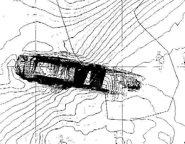
Picture 1 - The M/S Estonia on the bottom of the sea - picture given to Agnef spring 2000 by the Swedish National Maritime Administration The picture has North is upwards, thus East it to the right. You clearly see the outline of a wreck, size and shape of which is the M/S Estonia. The depth curve 84 metres passes below the bulbous bow and the depth curve 73 metres passes below the stern, thus the wreck lies on a sloping bottom - deeper at the East (right) end. However, the bottom depth curves seem to pass below the wreck and no real depth (barimetric) curves outline the wreck properly - the wreck should of course be represented by an underwater grounding, the top of which would be at about 55 metres depth, i.e. by thirty depth lines one meter apart starting at the bottom - 85 meters depth and ending at 55 meters depth.
Why the picture is misleading This writer thinks that sonar picture 1 above of the M/S Estonia wreck is a composite picture. It consists of a correct sonar (barimetric) picture of the sea floor (taken at an unknown date but probably 30 September 1994), where the depth curves are indicated and with a 'pyramid' shaped object on the bottom. It seems reasonable to assume that the picture/chart is based on information from the survey 30 September 1994. However - the depth curves of the wreck have been removed and the exact position of the wreck is not known. Somebody has then sketched in the outlines of the M/S Estonia wreck on top of the sonar picture and on top of the 'pyramid'. However - the wreck position cannot be correct - the centreline of the bow should be at 65 metres depth, which is not possible with the given depth curves of the bottom, e.g. 84 metres at the bow. The writer thinks that the visor was in fact found hanging from the bow on 30 September 1994. However, as the media had already then been told the story that the visor had fallen off the ship superstructure at least 40 minutes before the ship sank, the visor could evidently not be found hanging from the starboard superstructure of the wreck! The wreck had allegedly lost the visor and ripped the ramp fully open - then capsized (sic), then drifted two miles (>3 500 metres) (incl. a 180° turn) - evidently the visor could not be found on the wreck! The falsified plot of this is shown in 1.9 of the book Disaster Investigation. Therefore the Commission apparently denied that the visor had been found. To present its story that the visor had fallen off first, the Commission changed the wreck position - marked by a blue buoy - and then manipulated the finding of the visor as shown above 1994 - and produced the false barimetric charts 1996? Confusing to say the least. The visor was removed from the wreck under water early October 1994 using explosives! Why the above picture was handed out by the Swedish National Maritime Administration in the spring 2000 to the Agnef group was probably due to a clerical error. But why had somebody sketched in the wreck on the sonar picture in the first place? And why not simply delete the 'pyramid'? If we look at the wreck to the left of the 'pyramid', it looks like this: 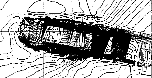
Picture 5 - the M/S Estonia on the bottom of the sea - close-up of the amidships and aft area (of picture 1) Parts of the plane surfaces of the wreck are blackened - why is not known. It is possible also here to remove the picture of the 'wreck' (outline, windows, funnel, the black spots and the confusing curves inside the outline) and to connect the depth curves North and South of the wreck to see the sea floor below the wreck. The result is something as follows: 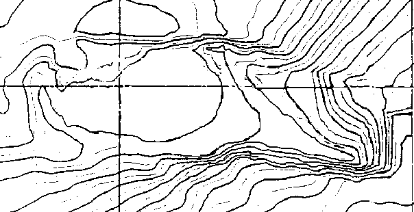
Picture 6 - the M/S Estonia on the bottom of the sea - close-up of the amidships and aft area with the 'wreck' removed It would thus appear that the picture of the 'wreck' was just added on top of the hydrographical (barimetric) chart of the sea floor. If the wreck actually was in suggested location is not certain. And why it was sketched in remains a mystery. But it seems that the sea floor forms a six metres deep depression where the starboard side deck house was located - or has also the depth curves been modified? The original depth curves could otherwise just be extended from the lower left corner to the upper right side showing a sloping bottom without a depression. Another picture is no 7 below. It is the original 'sonar picture' on top showing the 'wreck' at a list - say 120° - showing a bit of the flat bottom and with a profile drawing of the M/S Estonia (thus only 90° list) added below for comparison (not showing the flat bottom). The outline of the wreck fits quite well the profile drawing, e.g. the funnel is in the right position, but the bow area - with the 'pyramid' is strange. We cannot see the extension of the superstructure (the garage - car deck - decks# 2-4), forward of the deckhouse (decks# 4-8) front, with the ramp at the forward end on the 'wreck', because it is covered by the 'pyramid'. 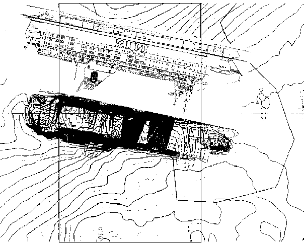
Picture 7 - the M/S Estonia on the bottom of the sea - profile of ship added below for comparison Anyway - if it had been a correct sonar (barimetric) picture, the 'wreck' would have been indicated by barimetric depth curves with the port bilge area at about 55 metres depth - see, e.g. picture no 11 below. The flat bottom of the 'wreck' would have been shown by parallel barimetric lines indicating a sloping wall or mountainside sticking up from the bottom. The port (upper) side would likewise have been shown by other parallel barimetric lines indicating a listing floor - the funnel would of course then have been - say 26 metres - below the port bilge, in the mud at about 79 metres depth, etc.
Drawings of the wreck on the bottom of the sea However - there are other descriptions of the wreck position at the bottom - one was established by the Dutch diving firm Smit-Tak 2-4 December 1994. See picture 8 below. According to Smit-Tak the wreck rests horizontally on the sloping bottom in the longitudinal direction with a 120° list sideways. The 'sonar' picture no. 1 above does evidently not represent the wreck shown below. There is no 'pyramid' shaped object at the bow! It is interesting to note that the whole hull of the wreck is above the seafloor and that it is the starboard superstructure and deck house that are submerged into the muddy bottom. Picture 8 - the M/S Estonia on the bottom of the sea - location as per Smit-Tak 10 December 1994 The Swedish National Maritime Administration has later informed that the 'sonar' picture (picture no 1) was made at an unknown date to prepare the covering of the wreck 1996. About 380 000 tons of sand and stones were deposited on the bottom around the wreck to secure it. On 21 July 1996 there was a mudslide south of the wreck and soon after the works to cover the wreck were abandoned. There are several other pictures of the M/S Estonia at the bottom of the sea - all taken November 1994 - July 1996. North is always upwards on the pictures. The below picture has been given to Heiwa Co by the Swedish Maritime administration. 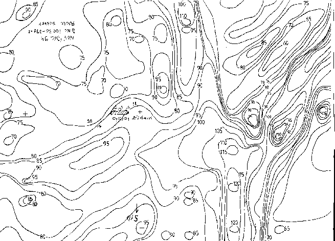
Picture 9 - the M/S Estonia on the bottom of the sea - location as per UDI-Wimpol Ltd. (Fugro Survey) 10 December 1994 In this picture the bottom at the bow is at 85 metres depth, but the bottom at the stern is at 80 metres depth, thus a 7 meters difference at the stern compared with picture no 1. The wreck is surrounded by six circles with a dot numbered 1 to 6.
The wreck is not horizontal Another picture is below. 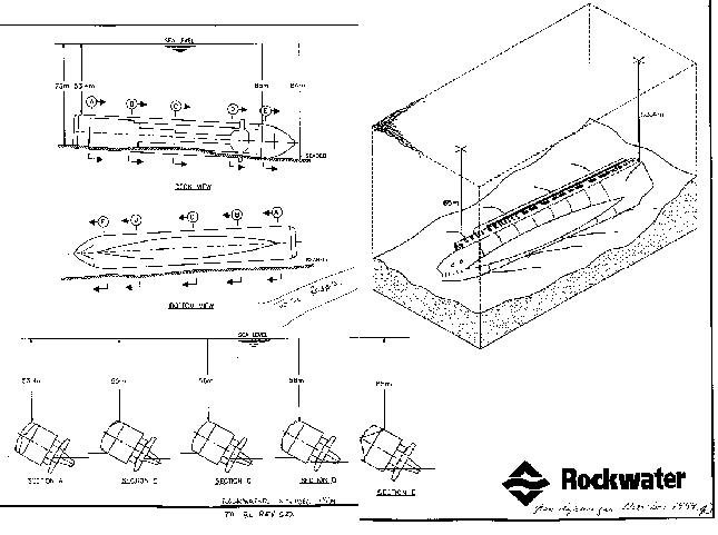
Picture 10 - the M/S Estonia on the bottom of the sea - location as per Rockwater10 December 1994 The quality of the picture is not so good, but it shows i.a. that the depth to the bottom at the bow is 84 metres, at the stern 73 metres and that the port bilge (the top) of the wreck is at 53.4 - 58 metres depth. It is quite similar to the Smit-Tak picture no 7 above, but the wreck is not horizontal. The whole underwater hull is above the mud line. Another real barimetric picture of the wreck and sea floor is the following. This picture is also provided by the Swedish Maritime administration. 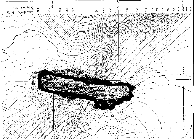
Picture 11 - the M/S Estonia on the bottom of the sea - location as per Jebsens-ACZ - Christmas/New Year 1995/6 On this picture the depth to the bottom at the bow is 85 metres and at the stern 73 metres. The funnel dips into the mud at 80 metres depth. There are correct barimetric lines on the hull - port bilge aft is at 56 metres, etc. i.e. there are no curves of the sea floor below the wreck. And there are no 'pyramid shaped' objects anywhere. The black outline of the hull is very close barimetric lines of sloping parts or reflections. Another picture provided by the Swedish Maritime administration shows echo soundings on and around the hull: 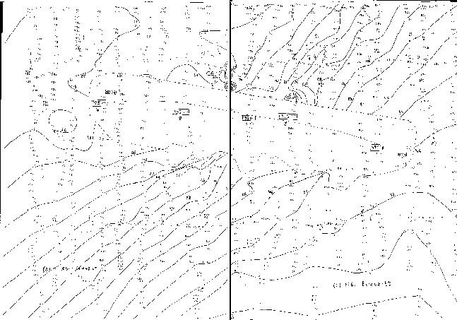
Picture 12 - the
M/S Estonia on the bottom of the sea - echo soundings as per
Fugro-Udi Ltd. 6 June 1995 (taken A rough outline of the wreck is pencilled in. The depth at the bow is 85 metres and at the stern 72 metres. The port bilge (top) of the wreck is at 53.4 - 57.3 metres - similar to picture 10 above.
The 'pyramid' is moving Picture 13 below maybe explains the mystery with the 'pyramid shaped' object at the bow: 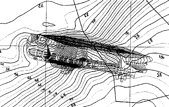
Picture 13 - the M/S Estonia on the bottom of the sea - as per Nordic Marine Contractors 10 September 1996 (based on measurements made 12 July 1996) Picture 13 is a part of sheet 3 (the only one available) of 11 drawings dated 10 September 1996 and provided by the Swedish Maritime administration. Here we see again a picture of the M/S Estonia sketched in on top of a barimetric chart of the sea floor - compare picture no 1 above. The sketch of the 'wreck' is much clearer - the flat bottom and the upper side of the wreck with windows are much clearer than in picture no 1. However, this time there is no 'pyramid shaped' object at the bow - it has disappeared. The barimetric curves at the bow and forward end of the deck house are also different - on picture 1 seven curves: 84, 83, 82, 81, 80, 79 and 78 metres, pass just below the bridge, picture 13 is completely different. The flare at the bow (on picture 13) seems excessive (but it is of course a sketch added on the picture) and the bow superstructure is not correctly sketched in. The depth curve 84 metres at the bow below the bulb is clear (on picture 1 it is above the bulb). It is anyway likely that also picture 1 was made by Nordic Marine Contractors. But the barimetric curves inside the outline of the hull are still confusing. Now - a 'pyramid shaped' object is seen under (or above?) the funnel! Let's take a closer look at it: 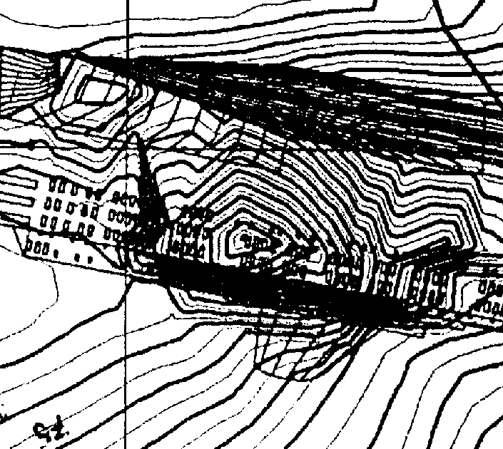
Picture 14 - the M/S Estonia on the bottom of the sea - as per Nordic Marine Contractors 10 September 1996 (based on measurements made 12 July 1996) - close-up of the deckhouse aft of the funnel The barimetric curves shown here are very confusing. There is a new 'pyramid shaped' object with its top (or bottom) at deck 5 - on the windows! - just aft of the funnel, not shown on picture 1! The 'pyramid' is described by 6 - 8 barimetric pyramid shaped curves one metre apart - maybe starting at 78 metres depth (the line crossing the funnel aft) and ending at 70-71 metres. There is also a small 'pyramid' at the stern! To see the new 'pyramids' better the outline of the 'wreck' (funnel, windows, etc.) is removed and you get something as follows (picture 15): 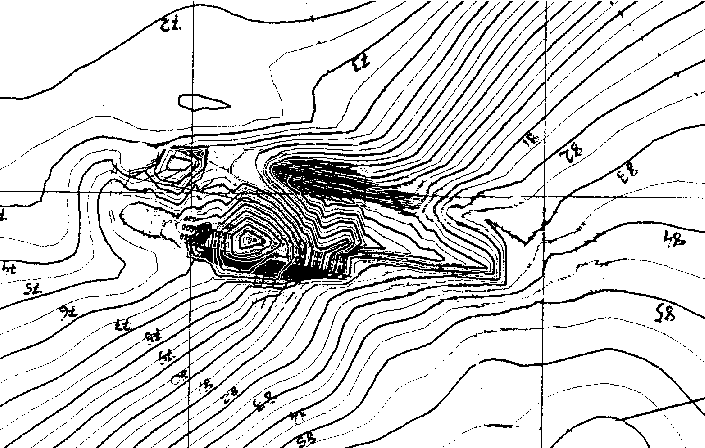
Picture 15 - the M/S Estonia on the bottom of the sea - as per Nordic Marine Contractors 10 September 1996 (based on measurements made 12 July 1996) - close-up of the deck house aft of the funnel with outline of deck house/funnel removed Compare picture 15 with picture 6. On picture 15 there is a 7-8 metres high 'pyramid' aft of the funnel on the sea floor - on picture 6 there is flat sea floor - no pyramid. But how can there be a 7-8 metres high pyramid below the wreck? Picture 13 (and 14) has been kindly submitted by the Swedish NMA to clarify picture 1 - that there was no visor (sic) at the bow of the wreck. However we still do not know, when the barimetric chart of the sea floor was done in pictures 1 and 13 and it is still unclear why there are 'pyramid shaped' objects at the bow or below the ship (deck 5 aft the funnel) and why the pictures 1 and 13 are different. There are theories that the wreck is not stable. Mr Johan Franson, director of safety at sea of the Swedish Maritime administration has stated to the Swedish daily Svenska Dagbladet (25 September 2001) that: "When we planned to cover the wreck (1996) seismic measurements were done. It was concluded that the ship rested stably. She had not moved at all" In retrospect the statement is very strange. The Swedish NMA has produced and published pictures of the sea floor, where the shape of the sea floor varies a lot - naturally the wreck cannot rest stably, if the sea floor changes. On 21 July 1996 there was a mud slide south of the wreck and soon after the works to cover the wreck were abandoned. It is clear that the bottom is not stable. Anyway - in August 2000 divers discovered damages at the bow, which have never been reported before! Read on!
How the visor was removed from the wreck Assuming that the visor was connected to the starboard side of the forward superstructure, when the ferry sank and that the visor slipped off the ferry, when it listed >90°, the visor thus turned upside down during the sinking without opening the ramp. It is then likely that the visor was still somehow connected to the starboard bow superstructure of the ferry at the bottom, when the wreck was found on 30 September 1994. It might have been hanging in its starboard lifting hydraulics. Therefore all video pictures of the starboard side, taken on 2 October 1994, had to be censured or cut out from the film. It has been reported in the Swedish press, that five Swedish navy divers, among them a Mr. H. Bergmark, probably led by Mr. Gustav Hanuliak, dived on the M/S Estonia in 1994. Mr. Hanuliak was also definitely aboard the dive vessels at the official dive expedition in December 1994 and at another expedition summer 1996. Mr. Hanuliak has then claimed in media reports, that he knows the full truth of the M/S Estonia accident! However - he has not told us, what the truth is. Mr Hanuliak has never reported that there is a big hole - opening - in the starboard superstructure front bulkhead. And the Commission has never reported about Hanuliak and his five divers. Nevertheless - it can be as simple as follows: The wreck was found by sonar on the 30 September and filmed by ROV on the 2 October 1994 and the visor was seen still attached on the starboard bow superstructure side. Thus only pictures of the port side and the centre line of the bow area, filmed on 2 October - figs. 8. 2/11/13/15/16 and 17 in the Final Report, could be made public. The pictures were taken at 63.2-65.2 metres depth. Mr. Hanuliak & Co. were perhaps ordered early October 1994 (a) to remove the visor from the wreck at the bottom of the sea and (b) to open the ramp - underwater. The visor was then already detached from the bow on the port side but was attached on the starboard side. The divers used Swedish (enemy) mine destruction explosive devices in the process. They free dived from a Swedish mine destruction vessel (HMS Furusund?) equipped with a dive pressure chamber (so that they could easily dive to the wreck and quickly return to the support ship, where they then recovered in the pressure chamber). This took place between 2 and 9 October 1994. The radio officer of HMS Furusund is the present head (admiral) of the Swedish navy! At that time a false wreck position had been announced 2.100 metres NE of the actual position - marked by the blue buoy - and the vessels 'guarding' the wreck were apparently anchored at that location (guarding the buoy!). Thus the Swedes could dive in peace and quiet at the real wreck position. The mission succeeded partly - the visor was removed (at say 70 metres depth and sank to the bottom of the sea at 84 metres depth below the bow of the wreck but they could not open the ramp - and several mistakes were made. 1. The divers left one unexploded device behind just outside the ramp on the port side - an orange 'box' seen on ROV-films dated 9 October 1994 (but not on ROV-films dated 2 October and 2-4 December 1994). 2. The divers attempted to open the ramp - but failed. The divers blow several small holes in the superstructure structure outside the ramp and inside the ramp - in the longitudinal bulkheads forming the 'tunnel' leading forward to the ramp - in their attempts to open the ramp. These damages were clearly seen and probably filmed, when the car deck was investigated by divers 2-4 December 1994. The Commission could therefore not inform about these damages.
The Commission has never during its investigation 1994-1997 nor in its two reports (April 1995 and December 1997) informed the public, that there is a big damage in the starboard superstructure front bulkhead (which does not apparently tie up with any damages higher up on the bulkhead or on the fore castle deck allegedly caused by the visor lifting hydraulic piston). This writer thinks that the hole in the starboard side superstructure bulkhead was blown by Swedish divers in October 1994 removing the visor under water. They then forgot an explosive charge - the orange box - situated at the port side at about the same place on the bulkhead. It should be recalled that the above damage is in the starboard superstructure front bulkhead, against which the visor rests in closed position. There is no open space between the visor and the bulkhead, when the visor is closed. Behind the bulkhead is a storeroom, where also the lifting hydraulics of the visor and its side lock are positioned. The ramp does no rest against the bulkhead with the hole - the ramp rests in closed position against a frame inside of the damage hole. Another mystery is what has happened 200 metres South of the wreck. Read on! Let's have another look at picture18 below - it is a larger version of picture 13. Note that the distance between the vertical and horizontal lines is 100 metres. North is up. 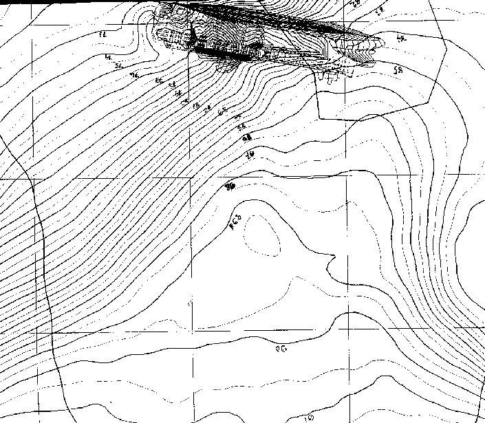
Picture 18 - the M/S Estonia on the bottom of the sea - as per Nordic Marine Contractors 10 September 1996 (based on measurements made 12 July 1996) The sea floor 100-250 metres South of the wreck (above it on picture 18) is a flat area at 89- 91 metres depth on 12 July 1996. There is no 'visor' at the bow. The Swedish government had decided on 20 June 1996 that all preparation work to cover the M/S Estonia wreck should stop immediately. The other charts taken 1994/6 above indicate the depth is 90-95 metres (e.g. picture 9). Let's then look at the famous Agnef picture (no 1) what it says of the same area: 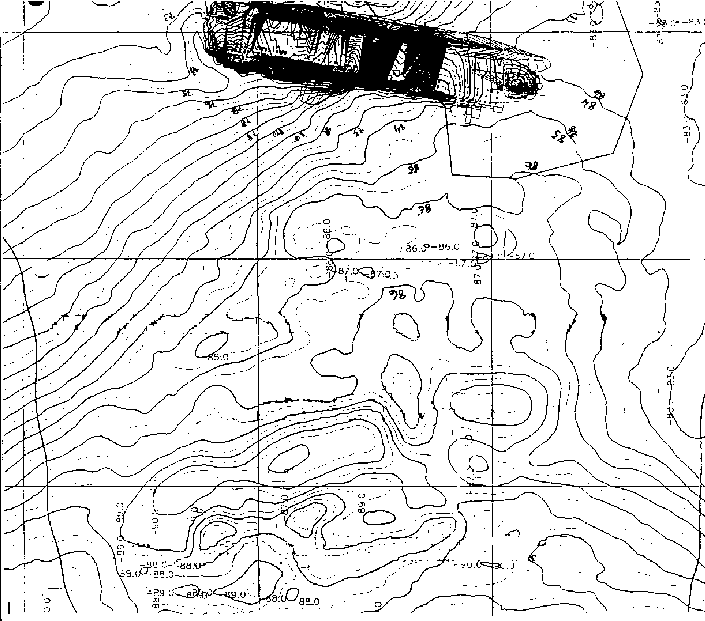
Picture 19 - the M/S Estonia on the bottom of the sea - the 'Agnef' picture with a 'visor' at the bow at unknown date Now the barimetric depth curves indicate that the sea floor 100-200 metres South of the wreck is at 86-87 metres depth, i.e. it seems to have been covered by 4-5 metres of sand and stones - 40 000 m3. It can of course be the result of the Nordic Marine Contractor's work to 'secure' the bottom around the wreck - in preparation to cover the wreck itself - but it can obviously also have been intended to cover something on the bottom itself. Is the pictures 1 (and 19 taken) after 12 July 1996? Why does it show a 'visor' at the bow? And if 380 000 tons of sand and stones were deposited around the wreck - where are they? It would be interesting to know why sand and stones were deposited 200 metres away from the wreck. And what happened after the Swedish government decided on 20 June 1996 that all underwater work should cease. The German group of experts believe that 'secret' military cargo on the M/S Estonia was thrown overboard through the starboard pilot door in the superstructure (picture no. 20) just prior to listing and sinking and that the Swedes and Finns announced a false wreck position and denied finding the visor early October 1994, so that they could search in peace and quiet for this lost cargo - which they never found - saying that they searched for the visor. Picture 20 - Pilot door at fr. 122 starboard side The area, where the 'secret' cargo was thrown overboard, could very well have been 100-250 meters South of the wreck because logically the M/S Estonia was floating there 15 minutes before she sank - or the 'secret' cargo was found elsewhere and deposited there. Regardless, we do not know for certain how the M/S Estonia drifted and sank. It is probable that she drifted from South to North, i.e. from the lower to the upper parts of the above pictures. At a certain time the stern hit bottom and she could not drift anymore. Then she might have rotated slowly around the stern until the bow sank below water. Who knows? The writer cannot make any sense of above information, but some conclusions can be made: A lot of barimetric pictures
have been made of the wreck at different times
showing different bottom configurations and
different positions of the wreck and strange
'pyramid' shaped objects at various places
on the wreck. The depth records of the various ROV
films do not tally with the depths indicated on the
barimetric charts. The wreck has been sketched in
later on many barimetric charts, i.e. its position
cannot be correct. No sand and stones have been
deposited on the wreck itself - most of the sand
and stones are apparently located 100-250 meters
South of the wreck. It is possible that 'something'
has been buried there. None of the barimetric
charts in pictures 1, 2, 3, 5, 6, 7, 13, 14, 15, 18
and 19 are however correct - they can show
anything; hand-made falsifications of unknown
purpose. Interestingly enough some
barimetric pictures show the buckle in the M/S
Estonia visor. A buckle? Yes, the M/S
Estonia visor has a big buckle (picture no. 21)
indicating that the M/S Estonia collided
with something before sinking. The wreck is
moving On 4 October 2001 the
following message was received from one of the
private divers having inspected the M/S
Estonia in August 2001: "We wanted primarily find the hole in the starboard superstructure side and therefore we have thoroughly inspected the ship's side back to the stabilizer - unfortunately the interesting position is still not accessible and we could find no hole - however it was very interesting to observe that the sea floor around the Estonia was quite different from a year ago - I am quite convinced that the wreck has turned (rotated). You could see totally about 1,5 meter more of the starboard side than one year earlier (the anchor pocket at the bow was completely free) - you are still always in the "blue" area and cannot reach the white area (above the car deck no 2). However you can already see the vertical side." It is of course quite possible that the wreck is moving, so that more of the starboard vertical superstructure side including the pilot door becomes visible. Another explanation may be that the sand and the mud on the sea floor itself have been swept away so that you can see more of the side. It has been suggested that somebody had poured sand at the starboard superstructure side to cover the pilot door and this sand is evidently not as packed and solid as the sea floor itself and can be swept away by currents. Read the whole incredible story in the Internet book 'Disaster Investigation' how the international Commission fooled the Estonian and Swedish public 1994-1997 how the M/S Estonia sank. Every essential piece of information was false or misleading. Not one word was true! Back to 'Disaster Investigation' Back to 'Lies and Truths about the M/V Estonia accident' To more info in English about the Estonia investigation
|