1.26 Unclear Route Planning - Turning Point - censored
The Final Report (5) has no information at all about the 250 earlier, identical voyages of the 'Estonia' with e.g. the normal route, e.g. following the Finnish coast as the ferries from Helsinki. The suggested courses/speeds in the Final Report of the last, fatal voyage, i.e. along the Estonian coast (see figure 1.26.1 below) are not proven and seems to have been a one off trip. Normally the 'Estonia' followed the Finnish coast! The Polish vessel the 'Amber' met the 'Estonia' on 27 September 1994 at about 23.15/23.20 hrs Estonian time at position N59°22,5', E22°35,4', when the 'Estonia' had course about 260/265°. It means that the official position of the 'turning point' and the time - 00.30 hrs - for reaching it cannot be correct 2.25.
The Independent Fact Group has convincingly shown that the Commission states completely incorrect courses, positions and speeds for the 'Estonia' before the accident (see http://factgroup.tripod.com and click on up-dates 01.02.11) in the Final report (5). According to the Fact Group:
"M/V Estonia departed on time at 19.00 hrs, and nothing abnormal was reported in the first and original witness statements, neither from the passengers nor from the crew, except from one witness stating that she was faster than normal. Her speed was about 18 knots. The ship left through the north exit where she suffered from hard wind and waves from the port side that caused a list to starboard. The course was 290° and the speed reduced to about 17 knots. At this time of the voyage she rolled quite a lot and it caused problem for the people in the restaurants. She was heading for the traffic zone outside the Porkkala fairway where she should change to a course more against the wind and waves.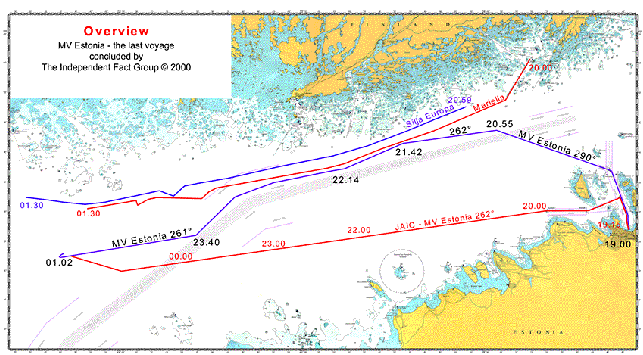
Figure 1.26.1 - The Fact Group suggested course of the 'Estonia' 27-28 September 1994
At 19.58 hrs she entered in to the Finnish surveillance information system MEVAT, and she consequently got the identification no. 1758. When she reached the west way bound zone at 20.55 hrs she altered the course to 262° and increased the speed to the maximum around 20 knots.
At 21.15 hrs both captains entered the bridge and stayed there for 20 - 30 minutes. At this time they were closing up to Mariella that came down from the northeast just ahead of Estonia. At 21.24 she is plotted by MEVAT from Russarö, identified as M/V Estonia. However there are two other unidentified ships very close to each other just behind Estonia at this time. All three ships are therefore identified being the same, M/V Estonia. The tracking is lost at 21.25, and that position is the only one that we have identified as originated from M/V Estonia. The presumed tracking of M/V Estonia continues however, but it is one or both of the unidentified ships that are tracked. They are only keeping a speed of around 13 knots and heading almost the same course as M/V Estonia.
At around 21.30 the passenger Rolf Sörman entered up to the 7 deck with his friends. When he came up from the stairway at deck 7 he passed the hall to the opposite side from the stairway diagonally to the left. He was subsequently heading toward the stern with the starboard side on his left. When they stood there, inside the hall, he saw, and read the illuminated name "MARIELLA" in yellowish color through the doors on his left side. As it was very dark outside he could not see which way the ships were heading, and he did believe he saw the ship on the port side of Estonia, and it looked as if Mariella was almost still. This can be explained by a slight alternation of the M/V Estonia course toward the south at 21.42 giving that visual effect.
At around 21.45 M/V Estonia was heading almost parallel with Mariella and Silja Europa.
At 22.14 she was in the position to be seen by Ingmar Eklund, mate on Mariella, 30° on her port side in the same time as Silja Europa is a bit further forward on Mariella's starboard side.
At around 22.50 M/V Estonia enters the point where she follows the traffic zone towards the southwest. At around 23.10 she has changed the course to 226° following the zone. This is a necessary change of the course to avoid risk of collision with the fleet coming from Stockholm and heading for the eastbound traffic zone in to the Gulf of Finland. On the way from Stockholm to Helsingfors this night were M/V Isabella and Silja Symphony.
At 23.40, after about 30 minutes on this course the last waypoint was reached, where M/V Estonia changed course to west, or more exactly to 261° heading straight on to Sandhamn and "Revensgrundet". Now she was heading straight in to the waves again and according to Einar Kuuk the stabilizers were activated and the speed decreased with 1 knot.
At 01.02 M/V Estonia suffers from the final damage and shortly thereafter she is lost."
The 'Estonia' should, according to the Fact Group, have departed at the normal time 19.00 hrs (not later as stated by the Commission) - and then crossed the Bay of Finland and turned West using the same courses and speeds of the ferries from Helsinki to Stockholm/Sweden via Söderarm (or Sandhamn).
The 'Mariella' and the 'Estonia' sail close together
Many testimonies support the Fact Group - both from persons on the 'Estonia' and on other ferries, e.g. the 'Mariella'. It means that the 'Estonia' for several hours between 20.00-24.00 hrs sailed the same course as the 'Mariella' and the 'Silja Europa' with a certain time gap (the 'Estonia' slipped in between the two ferries in the westward fairway south of the Finnish coast and slightly south of 'Mariella' and 'Silja Europe', which sailed faster). Then the 'Estonia' turned towards Sandhamn (sic) at about 23.40 hrs to end up at the accident position at about 01.00 hrs. Both the 'Mariella' and the 'Silja Europa' may have turned towards Sandhamn during the night (it was an alternative entry point to Stockholm), but then shortly afterwards changed their minds and continued to sail towards Söderarm. Why the Commission invented a completely different course for the 'Estonia' close to the Estonian North coast 19.00-00.30 hrs and then adding a course change to Söderarm at 00.30 hrs is not clear. The Fact Group shows clearly that there is no supporting evidence at all for the statements of the Commission re courses and speeds.
The 'Estonia' should then have listed to port (? - Factgroup probably means starboard) at 01.02 hrs and turned starboard, i.e. not to port 1.9 as per the Commission to avoid heading into waves and winds and should then have drifted to the wreck position close by. In these circumstances the 'Estonia' evidently never passed the 'position of the visor' another mile further west, which therefore also is false 1.14.
The route of the 'Estonia' before the accident is not proven.
The Weather was not extreme
And what about the weather? Why were not the weather during the previous 250 (or 500 if you include the Eastbound led) voyages investigated? The Commission suggested that the accident took place when the significant wave height was about 4,0-4,2 meters. The statistics are quite clear.
|
This wave height occurs about 3 days per year and much higher waves about 3-4 days. The 'Estonia' - and all the other ferries on the same trade, had therefore experienced similar or worse weather before - many times. Evidently the Masters of other ferries testified to this effect. Furthermore, a significant wave height of 4,1 meters does not correspond to very severe seas. Such waves will hardly impose any severe loads at all on a visor on a ferry type 'Estonia' at all, which is easy to test in full scale. Therefore the Commission had to simply falsify model tests and simulations to the contrary - that a force/load of >1 000 tons had struck the visor on the 'Estonia' Appendix 2. There is no possibility that 4,1 meters waves can knock off a visor on a ferry! Any impact on the visor will be heard all over the ferry and you have to slow down before anything happens to the visor. |
(wave period 6-10 seconds) |